Three things make a view
Walk from the white cliffs of Sussex to the red cliffs of Devon, or from the Yorkshire Dales to the Cotswolds, and the country changes character. The soil and the stone change colour and the hills change shape. In places stone walls give way to hedges, and streams that run along the surface start vanishing underground. Most of that comes down to the rock underneath, what the ice ages did to it and the weather it has had since. People are a fourth factor, and a bigger one than you might think, but mostly they worked with the ground they found.
Hard rock stands up as mountains and headlands, and soft rock wears down into vales and bays. Some rocks, chalk and limestone especially, soak up rain, so their hills are dry and their water runs underground. Others, like granite, slate and gritstone (a coarse sandstone), shed it, so the ground stays wet and acid, and bog and heather take over. Soil is mostly broken-down rock, so the rock also shapes what grows. People built their houses from it, too.
Britain has far more kinds of rock than you'd expect for its size. Travel from Cape Wrath to the Isle of Wight and you cross rocks from nearly every period of Earth's history, from the banded gneiss of the far north-west, around 3,000 million years old, to clays and sands around London that are only about 50 million years old. As a rule the rocks get younger and softer as you go south and east. A line from the mouth of the Tees to the mouth of the Exe, known as the Tees–Exe line, roughly splits Britain in two. North and west of it is upland Britain, where the rock is older and harder and the weather wetter, and south and east of it is lowland Britain. The line isn't exact (the North York Moors are on the lowland side), but it works surprisingly well.
Working out how old the rocks are took a long time. In 1788 James Hutton took two friends by boat to Siccar Point, on the Berwickshire coast, and showed them gently sloping red sandstone lying across the worn-off ends of older rock standing on end. The older layers had been laid down, buried, tilted, raised and worn flat before the sandstone settled on top, and that could only mean unimaginable stretches of time. One of the friends, John Playfair, wrote that the mind seemed to grow giddy “by looking so far into the abyss of time”.
The rocks also show how far Britain has travelled. The crust under it has been drifting slowly north for 500 million years. On the way its rocks formed in southern oceans, in coral seas and coal swamps near the equator, in deserts as dry as the Sahara and in warm shallow seas. That's how a cool northern island came to have tropical limestone and desert sandstone in it. Scotland and England even began on different continents, with an ocean between them that closed around 420 million years ago, roughly along the line of today's border.
For most of the last 2.6 million years Britain has been colder than now, and ice sheets spread and melted many times. The furthest-reaching got as far as what's now north London. The last one was at its largest roughly 27,000 to 23,000 years ago (different parts peaked at different times). It buried Scotland and most of Wales and northern England, and carved the mountains into the shapes you know. By about 15,000 years ago it had shrunk back into the hills, and a last cold spell brought glaciers back to the Highlands until about 11,700 years ago. Even where the ice never reached, the frozen ground left its marks.
Wet winds off the Atlantic drop most of their rain on the first high ground they meet, so the west is wet and the east is dry. Seathwaite in Borrowdale averages more than 3 metres of rain a year, while parts of Essex get barely half a metre. Where it rains most, the ground turns to bog rather than heath, moss grows thick in the oakwoods and the streams cut down faster.
The rock under Britain
Here's the rock of Great Britain in the families this page uses, youngest at the top of the key and oldest at the bottom, the way the layers stack up in the ground. Point at a rock in the key to find it on the map, or pick one to jump to its section.
YoungestPoint at a rock to find it on the map
- Clay, sand and gravelUnder 66 million years6%
- Chalk100–66 million years8%
- Greensand and Wealden rocks143–100 million years4%
- Jurassic limestone and clay201–143 million years11%
- New Red Sandstone299–201 million years11%
- Coal MeasuresAbout 320–300 million years6%
- Millstone Grit and other sandstonesAbout 350–315 million years4%
- Carboniferous Limestone359–330 million years4%
- Old Red Sandstone419–359 million years6%
- Slate, mudstone and grit539–300 million years15%
- Old volcanic rocksMostly 490–330 million years3%
- GraniteMostly 430–275 million years4%
- Basalt and other dark rockMostly 60–55 million years2%
- Highland schistAbout 1,000–470 million years13%
- Torridonian sandstoneAbout 1,200–1,000 million years1%
- Lewisian gneissAbout 3,000–1,700 million years2%
Oldest% = share of Great Britain's land
What the names on a geology map mean
Geology maps label their colours with names like Jurassic and Devonian. They're the names of stretches of time, and four of them come from Wales and Devon, because British geologists were among the first to sort out the order of the rocks. Adam Sedgwick named the Cambrian after Wales in 1835, and Roderick Murchison named the Silurian after a Welsh tribe the same year. Each man kept stretching his period to take in more rocks, until both claimed the same ones and the old friends fell out for good. In 1879 Charles Lapworth offered a way out, giving the disputed rocks a name of their own, after another Welsh tribe: the Ordovician. The first detailed geological map of a whole country was of England and Wales, drawn by a canal surveyor called William Smith and published in 1815. Geologists have been drawing maps like it ever since, the colourful patchworks you may have seen.
| Period | Million years ago | Named after | Where you'll meet it |
|---|---|---|---|
| Precambrian | Before 539 | Simply “before the Cambrian” | Gneiss, Torridonian sandstone and most Highland schist |
| Cambrian | 539–485 | Cambria, the Latin name for Wales | Welsh slate, the quartzite caps of Torridon |
| Ordovician | 485–444 | The Ordovices, a tribe of north Wales | Snowdon, the crags of the Lake District |
| Silurian | 444–419 | The Silures, a tribe of south Wales | The Southern Uplands, the Welsh borders |
| Devonian | 419–359 | Devon | Old Red Sandstone, the slates of Devon and Cornwall |
| Carboniferous | 359–299 | “Coal-bearing” | Limestone country, gritstone edges, the coalfields |
| Permian | 299–252 | Perm, a region of Russia | Red desert sandstone, the Durham coast |
| Triassic | 252–201 | “Threefold”, for its three layers in Germany | Devon's red cliffs, the Cheshire and Midland plains |
| Jurassic | 201–143 | The Jura mountains, on the French–Swiss border | Cotswold stone, the fossil coasts of Dorset and Yorkshire |
| Cretaceous | 143–66 | Creta, Latin for chalk | The chalk downs and white cliffs, the Weald |
| Palaeogene and Neogene | 66–2.6 | Greek for “old-born” and “new-born” | London Clay, the lavas of Skye and Mull |
| Quaternary | 2.6–now | “Fourth”, the last survivor of an old four-part scheme | The ice ages, and everything since |
The rocks
Britain's rock sorts into a dozen or so families, each with its own kind of country. Here they are roughly oldest first, which is also roughly north-west to south-east.
Gneiss and Torridonian sandstone
The oldest ground, in the far north-westLewisian gneiss: about 3,000–1,700 million yearsTorridonian sandstone: about 1,200–1,000 million years
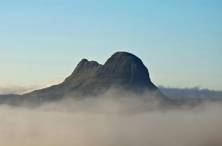
The oldest rock in Britain is Lewisian gneiss (say it “nice”), and some of it is around 3,000 million years old, about two-thirds the age of the Earth. Gneiss is rock that was buried so deep and heated so much that its minerals separated into streaky bands of grey and pink. The Outer Hebrides are made of it, and so is much of the coast from Cape Wrath down towards Skye. Gneiss is hard and holds hardly any soil, and the ice scraped it bare, so gneiss country is a jumble of low grey knolls with a lochan (a small loch) in almost every hollow, which geologists call knock-and-lochan.
In places the gneiss is capped by Torridonian sandstone, a dark red-brown rock laid down by rivers roughly 1,000 million years ago. Erosion has stripped most of the sandstone away, leaving a few mountains standing alone on the gneiss. Suilven and Stac Pollaidh are two of them, rising straight out of the moor with nothing around them. Beinn Eighe and the tops of Liathach are capped with pale quartzite, a very hard rock made from sand laid down in a shallow sea around 540 million years ago, and the quartzite scree (the loose stones on the slopes) can pass for snow from the road below. At Knockan Crag you can put your hand on the Moine Thrust, where much older rock was shoved up and over younger rock. When geologists worked out how that happened, in the 1880s, it helped explain how mountains are built.
Look for Bare grey rock with pink streaks, and mountains standing on their own like islands.
Where to see it Suilven , Stac Pollaidh , Liathach (Mullach an Rathain) , Beinn Eighe , South Lewis, Harris and North Uist
Highland schist
The worn-down roots of an old mountain rangeRock age: about 1,000–470 million years
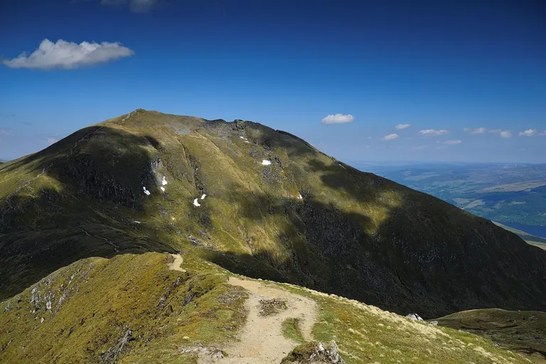
Most of the Highlands, from the far north down to the edge of the Central Belt (the lowland strip between Glasgow and Edinburgh), is schist and related rocks. They began as sand and mud laid down in ancient seas between about 1,000 and 480 million years ago, and were crushed and baked when continents collided around 470 million years ago. The collision threw up a great mountain range, and the Highlands are what's left of its roots after hundreds of millions of years of wear.
Schist glitters, because it's packed with flat flakes of mica, and it breaks along its layers. Highland hills tend to be big and rounded, cut by deep glens where the ice went through. Where the schist has a little lime in it, as on Ben Lawers, the soil is richer and the mountain flowers are some of the best in Britain. In 1774 the Astronomer Royal, Nevil Maskelyne, measured how far Schiehallion, a ridge of hard quartzite, pulled a plumb line off vertical, to work out how dense the Earth is. The mathematician Charles Hutton, working through the survey's measurements, joined up points of equal height with lines, an early use of contour lines.
Two great faults, long cracks where the crust has slipped, mark out the Highlands. The Great Glen, with Loch Ness in it, slices right across them from Inverness to Fort William, and the Highland Boundary Fault runs along their southern edge, crossing Loch Lomond at Balmaha, where Conic Hill and a string of islands line up along it.
Look for Rock that sparkles in the sun, and long, deep glens between big rounded hills.
Where to see it Ben Lawers , Schiehallion , Loch Rannoch and Glen Lyon, Loch Lomond , Knoydart
Slate and old volcanoes
Eryri, the Lake District and the Southern UplandsSlate, mudstone and grit: 539–300 million yearsOld volcanic rocks: mostly 490–330 million years
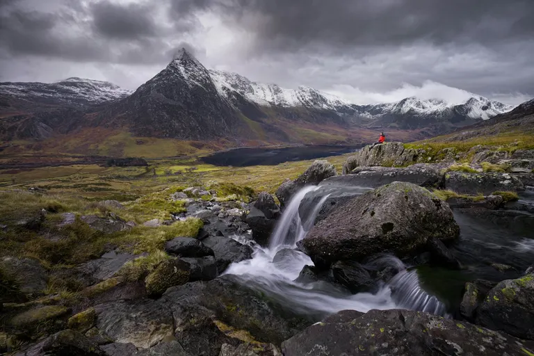
Wales, the Lake District and the Southern Uplands of Scotland are built mostly of rock made from mud and sand that settled on the sea floor between about 540 and 420 million years ago, along with the lava and ash of volcanoes that erupted into that sea. When the continents collided, the mud was squeezed into slate, which splits into thin, even sheets. By the 1890s north-west Wales produced nearly a third of the world's roofing slate, and the terraced quarries at Penrhyn, once the largest slate quarry in the world, and Dinorwig are now part of a World Heritage Site.
The volcanic rocks are tougher, and they make the craggy mountains. Yr Wyddfa (Snowdon) is largely volcanic ash that settled on the sea floor around 455 million years ago, which is why there are fossil seashells near the top of the highest mountain in Wales. In the Lake District you can see the two kinds of rock from the road. The smooth, rounded fells of the north, like Skiddaw, are old sea-floor mudstone, while the knobbly, rocky fells in the middle, Scafell Pike and Great Gable among them, are volcanic. Glen Coe is the collapsed centre of a later volcano.
Look for Grey-blue slate on the roofs, and old quarry tips on the hillsides.
Where to see it Yr Wyddfa , Tryfan , Penrhyn Quarry , Skiddaw , Scafell Pike , Ben Nevis and Glen Coe
Granite
Tors, moors and china clayRock age: mostly 430–275 million years
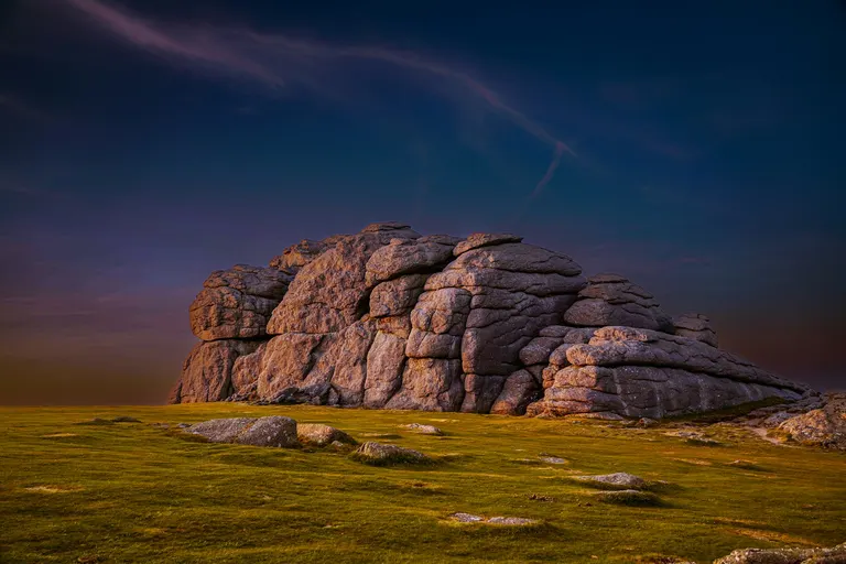
Granite started as molten rock that never reached the surface. It cooled slowly deep underground, so its crystals grew big enough to see. Look closely and you'll spot glassy grey quartz, white or pink crystals of feldspar and black flecks of mica. Dartmoor, Bodmin Moor, St Austell, the Land's End peninsula and the Isles of Scilly are all tops of the same huge body of granite, which rose under the south-west between about 295 and 275 million years ago and is joined up underground.
Granite is split by cracks called joints. Where they were close together, water seeping in rotted the rock into gravel, probably in the warmer climates before the ice ages, and frost and creeping soil stripped that rotten rock away in the cold spells that followed. Where the joints were far apart, solid blocks survived as tors, like Haytor and Hound Tor on Dartmoor, or the balanced stack of the Cheesewring on Bodmin Moor. The blocks that broke off still litter the slopes below; on Dartmoor they're known as clitter. Where hot fluids and weathering rotted the feldspar, it turned to kaolin, the white china clay that has been dug around St Austell since the 1700s, and the Eden Project is built in an old clay pit.
Granite makes acid, wet ground, so granite uplands are mostly moor. Scotland's Cairngorms are a great block of granite mountains more than 400 million years old, while Arran's Goatfell and the island of Lundy are young granites, only about 60 million years old.
Look for Grainy grey rock with big crystals, and tors on the hilltops with boulders strewn below.
Where to see it Haytor , Hound Tor , The Cheesewring , Land's End , The Cairngorm Mountains , Lundy
Basalt, lava and volcanic plugs
Lava fields, old volcanoes and the Whin SillRock age: mostly 60–55 million years
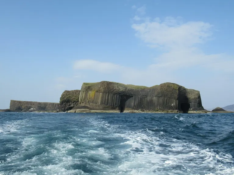
Basalt is dark, heavy lava that cooled quickly at the surface, which is why it's so fine-grained. Around 60 million years ago, as the North Atlantic began to open, lava poured out across the west of Scotland in layer after layer and made the dark, stepped country of Skye, Mull and the Small Isles. Where a thick flow cooled more slowly it shrank and cracked into columns, most of them six-sided, like the ones at Staffa and Fingal's Cave, part of the same great volcanic spell as the Giant's Causeway in Antrim.
Heavy lava on top of soft rock tends to slide. On Skye's Trotternish ridge the lava has slid downhill in huge blocks, and the pinnacles and hollows of the Quiraing and the Old Man of Storr are the remains of the biggest spread of landslips in Britain. The slide that left the Old Man standing happened only about 6,500 years ago. The Cuillin are the eroded plumbing of the same volcanoes, the chambers and pipes where molten rock cooled underground. The jagged Black Cuillin are mostly gabbro, a coarse, grippy rock that's popular with climbers (the thin dark bands of basalt through it are slippery when wet), and the smooth scree cones of the Red Cuillin next door are granite.
Older volcanoes left plugs, the hard rock that set in their throats. Arthur's Seat, in the middle of Edinburgh, is the remains of a volcano around 340 million years old, and Edinburgh Castle stands on a plug, with the Royal Mile running down the tail of rock the ice left behind it. Bass Rock and North Berwick Law are plugs too. Molten rock also forced its way sideways between layers and set as a sheet, the Whin Sill, around 295 million years ago. Hadrian's Wall runs along its clifftop at Sycamore Gap, Bamburgh Castle sits on it, and at High Force the Tees drops over it.
Look for Black rock in steps or columns, and isolated crags with castles on top.
Where to see it Staffa , The Quiraing , The Old Man of Storr , The Cuillin Hills , Arthur's Seat , Sycamore Gap
Old Red Sandstone
Bannau Brycheiniog, the Welsh borders and OrkneyRock age: 419–359 million years
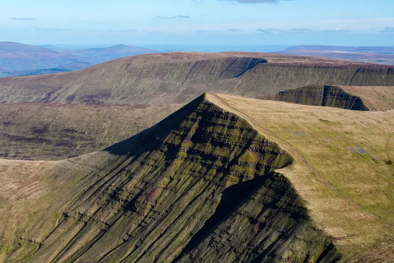
The Old Red Sandstone was laid down around 400 million years ago, when the pieces of Britain had just been jammed together and the land lay in the dry tropics south of the equator. Rivers pouring off the new mountains spread sand and pebbles across hot, dry plains, and the iron in the sand rusted red.
In Bannau Brycheiniog (the Brecon Beacons) its layers still lie almost flat, tilted gently to the south. The flat tops of Pen y Fan and Corn Du are a hard cap of sandstone and pebbly conglomerate (pebbles cemented into rock). Below it, alternating hard and soft beds stripe their north faces like a layer cake, and glaciers cut into the north side to make it steep. The red soil of Herefordshire and the Welsh borders comes from the same rock.
In the far north the Old Red Sandstone settled in a huge lake, in thin layers that split into flat slabs called flagstones. Orkney is made of it, and so are many of its buildings. The stone beds and dressers at Skara Brae and the standing stones of the Ring of Brodgar are flagstone, and the sea stacks (pillars of rock cut off from the cliff) at Yesnaby and the 137-metre Old Man of Hoy, which stands on a base of old lava, are Old Red Sandstone too.
Look for Rusty-red soil and stone, and flat-topped hills with stepped edges.
Where to see it Pen y Fan , Llyn y Fan Fach , Hay Bluff (Pen y Beacon) , Old Man of Hoy , Skara Brae , Stacks of Duncansby
Carboniferous Limestone
Scars, caves, gorges and pavementRock age: 359–330 million years
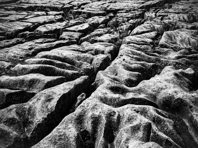
Limestone is made largely of the shells and skeletons of sea creatures. The Carboniferous Limestone formed around 340 million years ago, when Britain lay near the equator and much of it was under a clear, shallow tropical sea, something like the Bahamas today. Look at a wall in the Yorkshire Dales and you'll often find fossil sea lilies (animals related to starfish), whose stems look like little stacks of Polo mints.
Rainwater is very slightly acidic and slowly dissolves limestone, so in limestone country water runs through the rock rather than over it. It widens cracks into caves, and streams vanish underground. At Gaping Gill a beck (a stream) drops about 100 metres down a shaft, often called the highest unbroken waterfall in Britain, into one of the country's biggest cave chambers. Twice a year, in May and August, caving clubs rig a winch and lower visitors down. On bare ground the rain etches the rock into limestone pavement, blocks called clints split by deep cracks called grykes. The best-known stretch is on top of Malham Cove, a curving cliff about 70 metres high that had a waterfall pouring over it after the ice age, and briefly again during Storm Desmond in 2015. Gorges like Cheddar Gorge and Gordale Scar were cut by torrents of meltwater in the ice ages, when frozen ground stopped the water sinking in.
Limestone makes sweet (lime-rich), well-drained soil, so limestone country is green, with short, flowery turf, white stone walls and pale cliffs known in the north as scars. The White Peak in the middle of the Peak District is limestone, with Dovedale and Thor's Cave, and so are the Mendips, the Great Orme and the south Pembrokeshire coast, where the sea has cut the Green Bridge of Wales.
Look for Pale grey rock, bright green turf and streams that vanish into the ground.
Where to see it Malham Cove , Gordale Scar , Cheddar Gorge , Gaping Gill , Dovedale , Green Bridge of Wales
Gritstone and the coalfields
Edges, moors and mill townsMillstone Grit and other sandstones: about 350–315 million yearsCoal Measures: about 320–300 million years
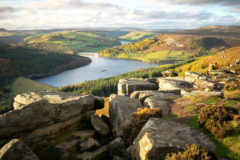
Millstone Grit is a coarse, gritty sandstone, tough enough to grind corn. It began around 320 million years ago as deltas of sand, spread across the old limestone seas by big rivers flowing from the north. Abandoned millstones still lie below Stanage Edge, and a millstone is the Peak District National Park's badge.
Grit is hard but sits on soft shale (a crumbly rock made of mud), so it weathers into edges like Stanage, Bamford Edge and the Roaches, long lines of cliff along the tops of the valleys. It also weathers into odd outcrops like Brimham Rocks and Ilkley's Cow and Calf. The soil on grit is acid and soggy, so the tops are heather and peat bog. Kinder Scout is gritstone, and the ring of dark moor around the Peak District's limestone middle is why the north of the park is called the Dark Peak.
On top of the grit came the Coal Measures, the buried and squashed remains of swamp forests of giant clubmosses and tree ferns. They're the rock of the old coalfields of South Wales, Yorkshire, the Midlands, Lancashire, the North East and central Scotland. The Pennine mill towns, Hebden Bridge among them, were built from gritstone, a buff-brown stone that two centuries of coal smoke turned black.
Look for Dark brown crags along the skyline, and black stone terraces in the valleys below.
Where to see it Stanage Edge , Bamford Edge , Kinder Scout , The Roaches , Brimham Rocks , Hebden Bridge
New Red Sandstone
Desert rock: Devon's red cliffs and the Midland plainsRock age: 299–201 million years
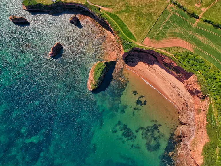
The New Red Sandstone (new only compared with the Old Red) formed between about 300 and 200 million years ago, when Britain drifted across the latitudes where the Sahara is now, and it was desert too, with sand dunes, flash floods and salt lakes. Its red comes from the same rust on every grain.
It's soft, so mostly it makes low, gentle farmland, like the Cheshire plain and the red earth of east Devon. Where the sea cuts into it you get the red cliffs and stacks of Ladram Bay and Sidmouth, and the Jurassic Coast, despite its name, starts in this older red rock at Exmouth. The round, smooth pebbles on the beach at Budleigh Salterton are falling out of an old river bed in the cliff; fossils inside them suggest the river brought them from mountains in what's now northern France.
The salt lakes left thick beds of rock salt under Cheshire, still mined at Winsford. The sandstone is soft enough to dig by hand. Nottingham sits on more than a thousand man-made caves, some of which you can visit at the City of Caves, and at Kinver Edge people lived in houses cut into the rock until the 1960s. Harder beds stand up as crags, like the one Beeston Castle sits on.
Look for Red soil in ploughed fields, and red sandstone churches and castles.
Where to see it Ladram Bay , Sidmouth , Budleigh Salterton, St Bees Head , Beeston Castle , Kinver Edge
Jurassic limestone and clay
Honey-coloured stone from Dorset to YorkshireRock age: 201–143 million years
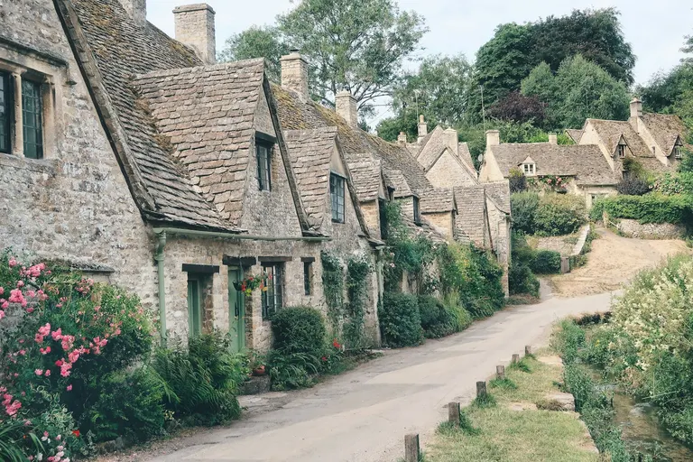
A belt of Jurassic clay and limestone runs diagonally across England, from the Dorset coast through the Cotswolds and the East Midlands to the North York Moors. The sea laid it down between about 200 and 143 million years ago, when much of Britain was under warm, shallow water full of ammonites (squid-like animals in coiled shells) and swimming reptiles.
The limestones are better known. Many are oolitic, made of tiny round grains like fish roe (oolite means egg-stone), and a little iron turns them gold. That's the stone of the Cotswolds, of Bibury and Castle Combe, and of the city of Bath. St Paul's Cathedral is built of Portland stone from the Dorset coast. The layers tilt gently to the south-east, so the hard limestone forms a ridge with a steep edge on one side and a long, gentle slope on the other. At Broadway Tower you're on the steep edge of the Cotswolds, looking west over the clay vale below, and the villages behind you are spread down the gentle side. The same pattern of hard ridge and soft vale repeats all the way to London.
The clays wear into wide, heavy vales, and where they meet the sea they crumble and slump, spilling fossils. Lyme Regis, Kimmeridge Bay and Robin Hood's Bay are all fossil beaches. At Lyme Regis, Mary Anning and her brother found the first skeleton of an ichthyosaur (a dolphin-shaped sea reptile) to be properly studied. In the north the Jurassic rocks turn to sandstone, and the North York Moors are a high sandstone plateau; there's more on why that's moorland further down.
Look for Honey-gold stone villages, and a steep edge with a wide vale below it.
Where to see it Bibury , Broadway Tower , Castle Combe , Lyme Regis , Robin Hood's Bay , Lincoln Cathedral
Chalk
Downs, wolds and white cliffsRock age: 100–66 million years
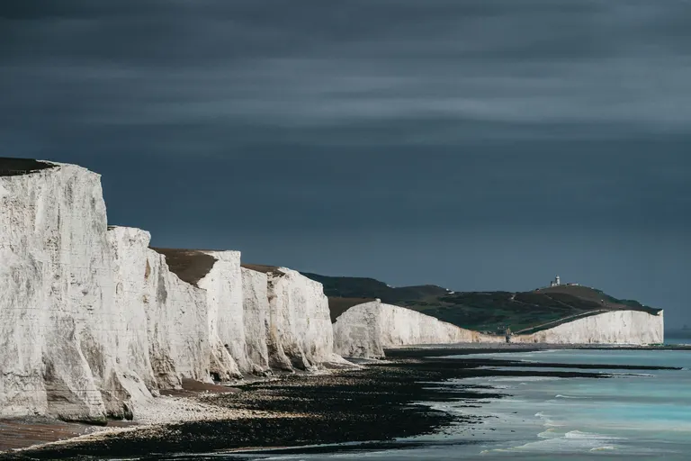
Chalk formed between about 100 and 66 million years ago, when sea levels were far higher than today and most of Britain lay under a clear sea. Floating in it were countless microscopic algae, each wrapped in tiny plates of lime, and when they died the plates settled on the sea floor. Over millions of years they piled up hundreds of metres thick, and a lump of chalk is mostly those plates.
Chalk is soft, but it soaks up rain like a sponge, so there's little water running over it to wear it away. The North and South Downs, the Chilterns, Salisbury Plain and the Wolds of Lincolnshire and Yorkshire are all chalk, long smooth hills with almost no streams. Downland, as this country is called, is short, springy turf grazed by sheep for thousands of years, full of wild orchids and blue butterflies, with beech woods on the steeper slopes. The dry valleys in the downs, like Devil's Dyke near Brighton, were largely carved in the ice ages, when frozen ground made the meltwater run over the surface.
Where the chalk meets the sea it makes white cliffs, at the Seven Sisters, the White Cliffs of Dover, Old Harry Rocks and Flamborough Head. The dark lumps in the cliff face are flint, which formed inside the chalk from the silica of long-dead sponges. Stone Age people made tools from flint and mined it at Grime's Graves, and later builders used it for the walls and churches of chalk country. Scrape off the turf and you reach bright white rock, which is how the Uffington White Horse was made.
Look for White rock showing through the turf, and flints in the fields and walls.
The Weald and the greensand
A dome with its top worn offRock age: 143–100 million years
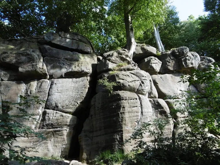
Between the North and South Downs lies the Weald, and its layout is a puzzle until you know the trick. Tens of millions of years ago the slow collision of Africa and Europe, the one that raised the Alps and the Pyrenees, bent the rock layers of south-east England up into a long dome. Rain and rivers then wore the top off, stripping the chalk away and exposing the older sands and clays inside. The North and South Downs are the two chalk rims of the dome, facing each other across the Weald with their steep sides turned inwards.
Inside the rims the rocks come round in rings. First comes a ridge of greensand, a sandstone that's green when freshly dug, from a mineral called glauconite, but weathers rusty orange. Leith Hill, the highest point in Surrey, and Black Down, the highest in Sussex, are both on this ridge, and springs seeping from the sandstone carved the Devil's Punch Bowl. Next comes the Low Weald, flat, heavy clay country thick with oaks; oak grows so readily across the Weald that it's nicknamed the Sussex weed. In the middle is the High Weald, a tangle of sandstone ridges and steep wooded ghylls (stream gullies), with outcrops like Harrison's Rocks and High Rocks and the heath of Ashdown Forest on top.
The Weald's iron-rich rock made it one of Britain's main iron-making regions twice, under the Romans and again in Tudor times, when streams were dammed into hammer ponds to drive the forges and ironmasters there cast cannon. Iguanodon was found in its rocks too. Gideon and Mary Ann Mantell found its teeth near Cuckfield in the early 1820s, and in 1825 it became only the second dinosaur ever named.
Look for Orange sandy soil and sunken lanes between small hilly fields and woods.
Where to see it Harrison's Rocks , Ashdown Forest , Leith Hill Tower , Devil's Punch Bowl , High Rocks, High Weald
Clay, sand and gravel
Soft ground around London, Hampshire and East AngliaRock age: Under 66 million years
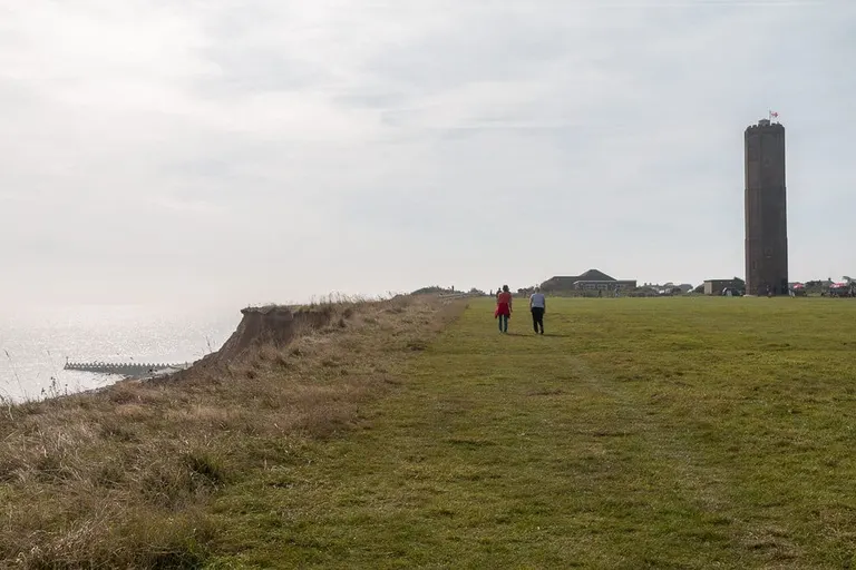
Most of Britain's youngest rocks, the sands and clays of the last 66 million years, lie in two shallow basins either side of the chalk, one under London and one under Hampshire and the Isle of Wight, and across much of East Anglia. London stands on London Clay, a stiff blue-grey clay, and on the Essex coast at the Naze it crumbles out of the cliff with fossil sharks' teeth in it.
The sands and gravels make poor, acid soil that was rarely worth ploughing, which is why so many of them are heath and common, like the New Forest, the Surrey heaths and Richmond Park. In East Anglia the soft rock is topped with clay and gravel dumped by the ice, and the sea wears the cliffs away easily. Most of the medieval port of Dunwich now lies offshore, and the cliffs at Happisburgh can lose metres in a year. In 2013 a storm there uncovered footprints left by a small group of adults and children somewhere between 850,000 and 950,000 years ago. They're the oldest known human footprints outside Africa, and the tide washed them away within weeks.
Look for Sticky clay and sandy commons inland, crumbling cliffs on the coast.
Where to see it The Naze , New Forest , Richmond Park , Dunwich Heath , Happisburgh
What the ice did
The maps in this section show the furthest the last ice sheet reached, drawn over today's coastline. Its edges hit their limits at different times, mostly between about 30,000 and 22,000 years ago, and the sea was so low then that much of the North Sea was dry land.
Carved by ice
Corries, U-shaped valleys, knife-edge ridges and long lakes
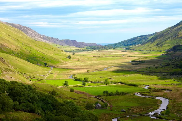
The last ice sheet buried Scotland, most of northern England and Wales, and the Irish Sea, and pushed as far south as the Isles of Scilly and the north Norfolk coast. Moving ice, full of rocks, works like very slow, very heavy sandpaper, and it reshaped everything it went over. It turned river valleys, which are V-shaped, into broad U-shaped troughs like Nant Ffrancon and Glen Coe.
High up, small glaciers scooped out armchair-shaped hollows called corries (cwm in Welsh, coire in Gaelic), and many now hold a lake, as at Cwm Idwal, Red Tarn below Helvellyn and Llyn y Fan Fach. Where corries were cut into a ridge from both sides they left a knife-edge between them, like Striding Edge or Crib Goch. The long lakes of the Lake District, like Windermere and Wast Water, fill basins the ice gouged out of the valley floors.
When the ice melted it dropped whatever it held. Boulders were set down on rock of a different kind; geologists call them erratics. The Norber Erratics are dark boulders 100 million years older than the pale limestone they sit on, and some now perch on little pedestals where the limestone around them has since dissolved. Blankets of stony clay, called boulder clay or till, cover much of lowland Britain, some of it left by earlier, bigger ice sheets. Side valleys were left hanging above the deepened main valleys, and their streams now fall off the edge (there's more on that under waterfalls).
Look for Flat-bottomed valleys with steep sides, and boulders that don't match the ground they sit on.
Where to see it Nant Ffrancon Pass , Cwm Idwal and Devil's Kitchen , Red Tarn, Crib Goch , Wast Water , Norber Erratics
Beyond the ice: the frozen south
Dry valleys, meltwater gorges and tors
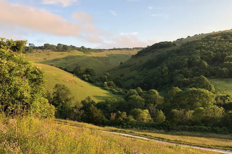
South of the ice, the ground froze many metres deep and stayed frozen for thousands of years at a time, as it does in Siberia now. Frozen chalk and limestone can't soak anything up, so the summer melt ran over the surface and helped cut valleys that are dry today, because the rain sinks in again. The smooth combes (dry valleys) of the downs, like Devil's Dyke and the Manger below the Uffington White Horse, were largely made this way, and so were limestone gorges like Cheddar, and probably Winnats Pass.
Freezing and thawing, night after night, split rock along its cracks. On Dartmoor frost prised blocks off tors like Hound Tor, and the blocks slid down the slopes. Each thaw let sodden soil creep downhill and smooth the land into the soft, rounded shapes of so much of southern England.
An earlier ice sheet, around 450,000 years ago, came further south than the last one and reached what's now north London, at Finchley and Hornchurch. The ice blocked the Thames, which used to flow through the Vale of St Albans, and pushed the river into roughly its present course. Around the same time a lake dammed by the ice in the southern North Sea spilled over the chalk ridge that joined Dover to Calais, and later floods broke the ridge open. That was the first step towards Britain becoming an island.
Look for Dry valleys with no stream in them, and gorges with no river big enough to have cut them.
Where to see it Devil's Dyke and Saddlescombe , Uffington White Horse , Cheddar Gorge , Winnats Pass , Hound Tor
Water, weather and what grows
The rock and the ice made the hills and valleys. What grows on them depends largely on the rain, and on what people have done since.
Moorland and bog
Why Dartmoor and the North York Moors look alike
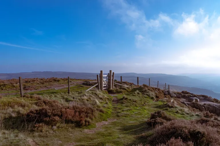
Dartmoor is granite, the North York Moors are Jurassic sandstone, the Dark Peak is gritstone and Exmoor is old slate and sandstone, yet all four are moors. They're high, open and treeless, purple and brown with heather and grass, and boggy in the hollows. What they share, whatever the rock, is thin, acid soil that loses its goodness easily, enough height to catch plenty of rain and cloud, and thousands of years of farming.
Much of Britain's moorland was wooded once; only the highest, windiest tops never grew trees. Farmers cleared the woods in the Stone Age and Bronze Age, for grazing and crops, and on Dartmoor you can still trace their round houses and long, straight field boundaries, laid out around 1700 to 1500 BC, on moorland no one ploughs today. Without trees the rain washed the goodness out of the thin soil and waterlogged it, and peat began to form. Peat is mostly dead moss that can't rot in the wet, and it builds up about half a millimetre to a millimetre a year, so a metre of peat takes one to two thousand years. Sheep eat the seedlings, and on grouse moors keepers burn old heather in patches, so the trees haven't come back.
The differences between the moors are mostly about rain. The North York Moors, the largest continuous stretch of heather moorland in England, are drier than Dartmoor, so they're mostly heather, while wetter Dartmoor and Exmoor's high Chains have more grass and bog.
The wettest moors are almost all blanket bog, peat that covers the land like a blanket, slopes as well as hollows. It needs rain on 160 or more days a year. Kinder Scout is a gritstone plateau covered in peat, and the Flow Country of Caithness and Sutherland, which you can walk into at Forsinard, is the largest stretch of blanket bog in Europe, made a World Heritage Site in 2024. Healthy bogs lock away huge amounts of carbon, which is why so many old drainage ditches on the moors are now being blocked up.
Look for Heather and cotton grass, dark peat banks and the stone rings of old round houses.
Where to see it North York Moors , Dartmoor , Exmoor , Kinder Scout , Forsinard Flows, Ilkley Moor
Temperate rainforest
The mossy oakwoods of the wet west
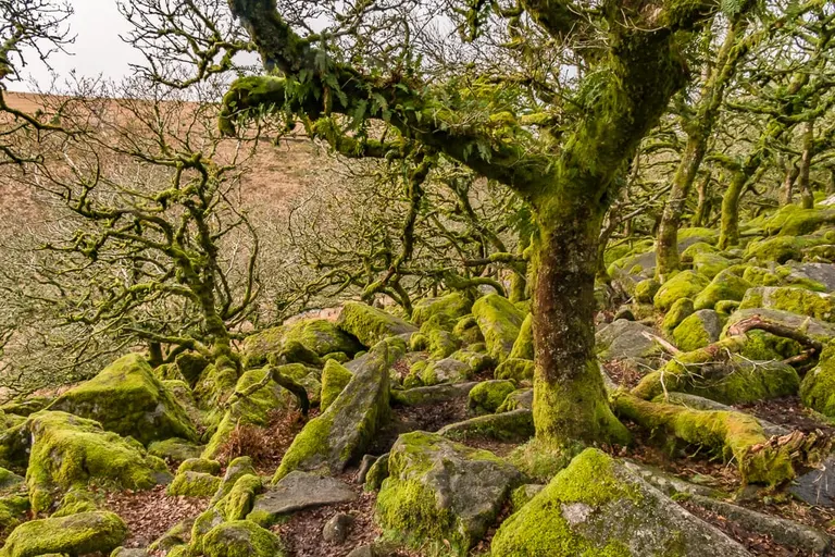
Britain has rainforest. It's woodland in places so mild and wet, with rain right through the year and damp, clean air, that mosses, liverworts, ferns and lichens cover the branches and boulders. This kind of woodland is called temperate or Atlantic rainforest, and in Britain it's mostly old oak, birch and hazel on the western fringes, from the west Highlands and islands down through Eryri and Cumbria to Devon and Cornwall.
Wistman's Wood on Dartmoor is a good place to start, stunted oaks growing out of a jumble of granite boulders, with moss on almost every surface. Walk round it rather than through it, because the mosses on the boulders are easily damaged and Natural England asks visitors to keep to the edge. There's more at Horner Wood on Exmoor, in the gorges at Lydford and Golitha Falls, in Borrowdale, where the Borrowdale Rainforest became a National Nature Reserve in 2024, and along the Argyll coast at Taynish.
Only fragments are left. Guy Shrubsole, who mapped them for his book The Lost Rainforests of Britain, reckons about a fifth of Britain has the right climate for rainforest but less than 1% is covered by it now; the rest was felled, planted with conifers or grazed so hard that no young trees could grow. The lichens are a good sign of clean air, since big leafy ones like tree lungwort grow only where there's very little pollution.
Look for Moss on everything, and ferns growing along the branches.
Where to see it Wistman's Wood , Horner Wood , Lydford Gorge , Golitha Falls , Borrowdale , Taynish
Caledonian pinewood
What's left of the Highland forest
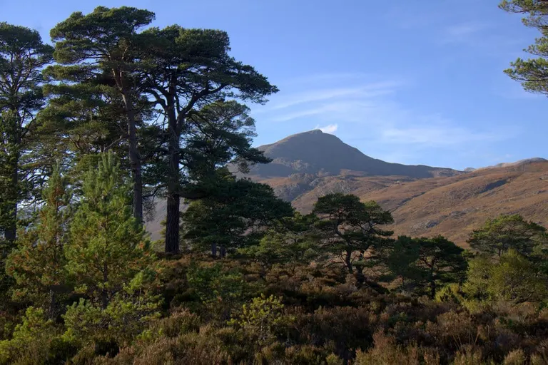
After the ice melted, Scots pine spread across the Highlands, mixed with birch, rowan and juniper. The pine forest was never one unbroken wood, more a patchwork of wood, bog and open hill. A cooler, wetter climate began its decline, and felling, farming and centuries of browsing by deer and sheep did the rest, leaving about 18,000 hectares in 84 scattered pieces, a few per cent of what there once was. Those fragments are some of the wildest woods in Britain.
Old native pines look nothing like a timber plantation. They're broad and branchy, often flat-topped, with orange-red bark high up and heather and blaeberry (bilberry) underneath, and the trees are spaced out, young and old together. Some of the best remnants are at Rothiemurchus and Loch an Eilein near Aviemore, at Abernethy around Loch Garten, in Glen Affric, in the Black Wood of Rannoch and at Beinn Eighe, which in 1951 became Britain's first National Nature Reserve. The pinewoods are home to red squirrels, pine martens, capercaillie (a turkey-sized grouse), crested tits and the Scottish crossbill, usually counted as the only bird that lives in Britain and nowhere else.
Look for Broad old pines with flat tops and red bark, and blaeberry underfoot.
Where to see it Glen Affric , Rothiemurchus Estate , Loch an Eilein , Loch Garten, Beinn Eighe
The arctic tops
Britain's patch of tundra
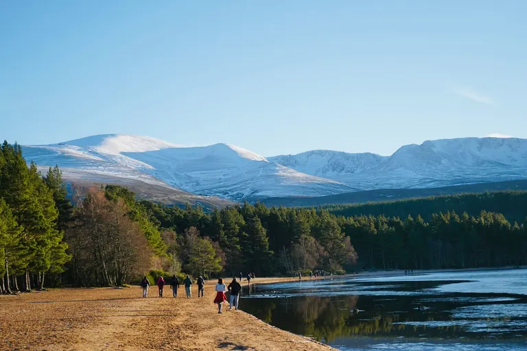
Climb high enough in the Highlands and you walk out of Britain's climate into something much closer to the Arctic. The Cairngorm plateau, a thousand metres and more up, often keeps its snow for half the year, and it has had some of the strongest winds ever measured in Britain (a gust of 173 mph on the summit of Cairn Gorm in 1986). The ground up there is covered in low, wind-clipped mosses, lichens and dwarf shrubs, like tundra. Dotterel, ptarmigan and snow bunting, all Arctic birds, nest there too. Until recently a few snow patches in the high corries survived most summers, but the most famous, on Braeriach, melted away every summer from 2021 to 2025. The plateau is serious ground, and the weather up there can turn in minutes.
Lower down, arctic-alpine plants (mountain flowers that also grow in the Arctic) cling on in cold, damp cliffs and corries, survivors from just after the ice age, when plants like them grew across much of Britain. Ben Lawers is famous for them, and you can see them on the ledges at Cwm Idwal. The Snowdon lily grows in Eryri and nowhere else in Britain. There's even a herd of reindeer, brought back to the Cairngorms in 1952; you can meet them through the reindeer centre.
Look for Tiny cushion plants on a stony plateau, and snow lingering in the corries into early summer.
Where to see it The Cairngorm Mountains , Ben Macdui , Cairngorm Reindeer Centre , Ben Lawers , Cwm Idwal and Devil's Kitchen
Lowland heath
Heather on sand, made by people
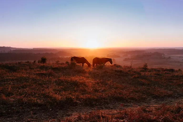
Heath looks wild, but it's one of the most man-made landscapes in Britain. It grows on poor, sandy or gravelly soil, like the young sands of the New Forest and Dorset or the Weald's sandstone. Bronze Age farmers cleared the woods there, the thin soil soon wore out, and for the next few thousand years people kept it open by grazing animals and cutting the gorse, bracken, heather and turf for fuel and bedding. When the grazing and cutting stop, birch and pine move back in within a generation, which is what happened to much of Britain's heath in the last century. Britain has lost around 80% of its lowland heath since 1800.
The heath that survives is precious. It's purple with heather in August and yellow with gorse for much of the year, and Britain's rarest reptiles live on it. The Dorset heaths are among the few places with all six native reptile species, including the sand lizard and the smooth snake. You can walk on heath in the New Forest, in Ashdown Forest, behind the beach at Studland, at Dunwich and in the sandy Brecks around Thetford Forest.
Look for Heather and gorse on low, sandy ground, and ponies or cattle grazing loose.
Where to see it New Forest , Ashdown Forest , Studland , Dunwich Heath , Thetford Forest
Chalk streams
Gin-clear rivers fed from underground
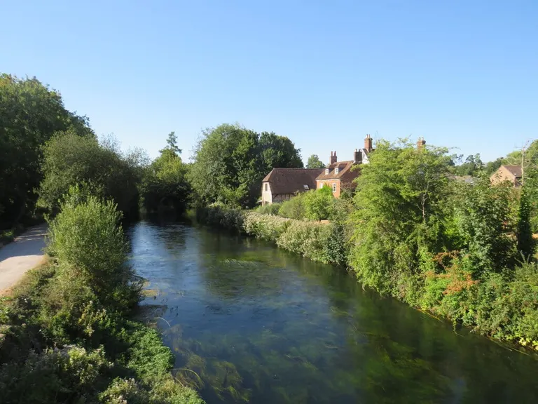
Rain that falls on chalk soaks into the rock, then seeps out months later from springs at the foot of the hills. A river fed that way runs almost perfectly clear, at much the same temperature summer and winter, and rarely floods or dries up. Rivers like that are called chalk streams. England has about 85% of the world's, and most of the rest are just across the Channel in Normandy.
In the clear, lime-rich water, water-crowfoot grows in swaying beds, white with flowers in early summer, and there are plenty of insects for the trout. The Hampshire chalk streams, the Test and the Itchen, are famous for dry-fly fishing, which was developed there in the 1800s, and the Kennet and Lambourn in Berkshire and the Wensum in Norfolk are chalk rivers too. Near their sources many chalk streams flow only in winter and spring, when the water in the chalk rises high enough, and they're called winterbournes, as in the Dorset village of Winterbourne Abbas.
Look for Water so clear you can count the weed and the fish.
Where to see it River Test, River Itchen, River Kennet, River Lambourn, River Wensum
Waterfalls
Hard rock over soft, and valleys left hanging
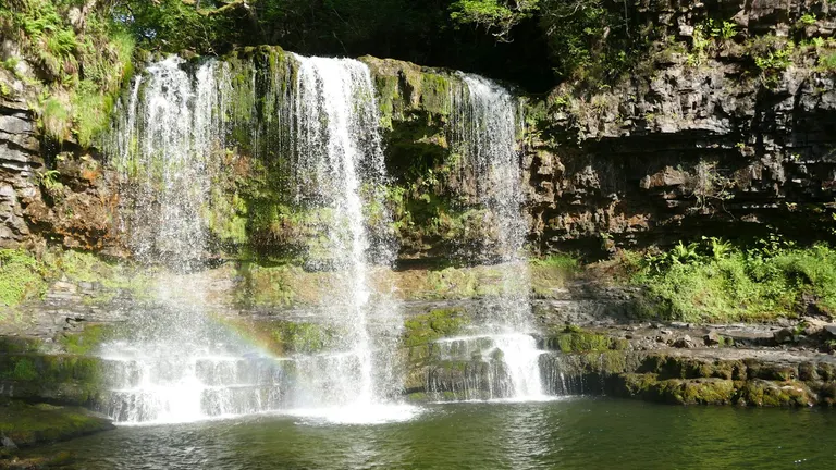
Most waterfalls form in one of two ways. The first needs a band of hard rock lying on softer rock. The river wears the soft rock away underneath, the hard lip overhangs and every so often breaks off, and the fall creeps slowly upstream, leaving a gorge below it. High Force, where the Tees drops over the Whin Sill, formed this way, and so did the falls of Waterfall Country around Ystradfellte, where the Mellte, Hepste and their neighbours cross hard sandstone lying on soft shale. At Sgwd yr Eira the soft rock under the ledge has worn back so far that you can walk behind the water on a path (it's impassable when the river is in flood). Henrhyd Falls nearby, 27 metres tall and the highest in south Wales, is where Batman's cave had its entrance in The Dark Knight Rises. In the Yorkshire Dales, repeating bands of limestone, sandstone and shale make the stepped falls at Aysgarth and the long single drop of Hardraw Force.
The second way is ice. A big glacier deepened its main valley far more than the small glaciers feeding it from the side, so when the ice melted the side valleys were left hanging, and their streams now pour off the lip. Steall Falls in Glen Nevis and the Grey Mare's Tail near Moffat come down from hanging valleys, and so does Britain's highest waterfall, Eas a' Chual Aluinn in Sutherland, which drops about 200 metres in a series of steps.
Either way, waterfalls are at their best after a wet spell, and the wet west has far more of them than the dry east.
Look for A hard ledge with an overhang, or a side valley that ends in a cliff.
Where to see it Sgwd yr Eira , Henrhyd Falls , High Force , Aysgarth Falls , Steall Falls , Grey Mare's Tail
Fens, levels and broads
The flat country, and who drained it
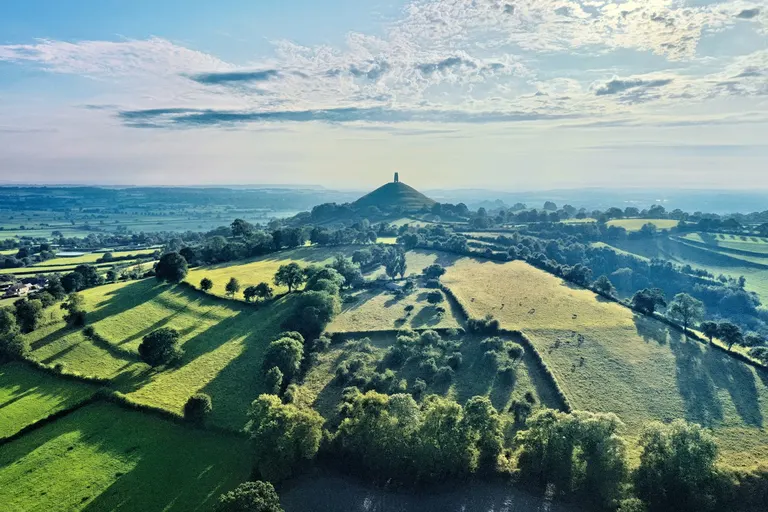
The Fens around the Wash, the Somerset Levels, Romney Marsh and the Norfolk Broads, the flattest parts of Britain, are all old wetlands. As the sea rose after the ice age it backed up the rivers, and for thousands of years these places were marsh and reedbed, building up thick layers of peat and silt. Then people drained them. The biggest job was the Fens, where the Dutch engineer Cornelius Vermuyden cut long, dead-straight drains in the 1630s and 1650s for the Earls of Bedford. Drained peat dries and shrinks, so the fields sank below the rivers and needed pumping, first by hundreds of windmills and then by steam. At Holme Fen, a post set level with the ground around 1850 now sticks out about four metres above it, and the land there, about 2.75 metres below sea level, is the lowest in Great Britain. Wicken Fen, the National Trust's first nature reserve, is part of the tiny fraction of the Fens never drained.
Hills in the Fens and the Levels were islands once, and many still look it. Ely Cathedral stands on a low island of clay capped with sand (Ely means eel district), and Glastonbury Tor and Burrow Mump rise out of the Somerset Levels, which still flood in a wet winter. The Broads are man-made. In the 1950s the botanist Joyce Lambert showed that they're medieval peat pits, dug for fuel and abandoned as they flooded.
Look for Dead-straight drains, and roads raised on banks above black peat fields.
Where to see it Wicken Fen , Ely Cathedral , Glastonbury Tor , The Broads , Hickling Broad
Where land meets sea
The coast is one of the best places to see what Britain is made of, because the sea keeps cutting the land back to a fresh face.
Sand, shingle or rock
Why one beach is pebbles and the next is sand
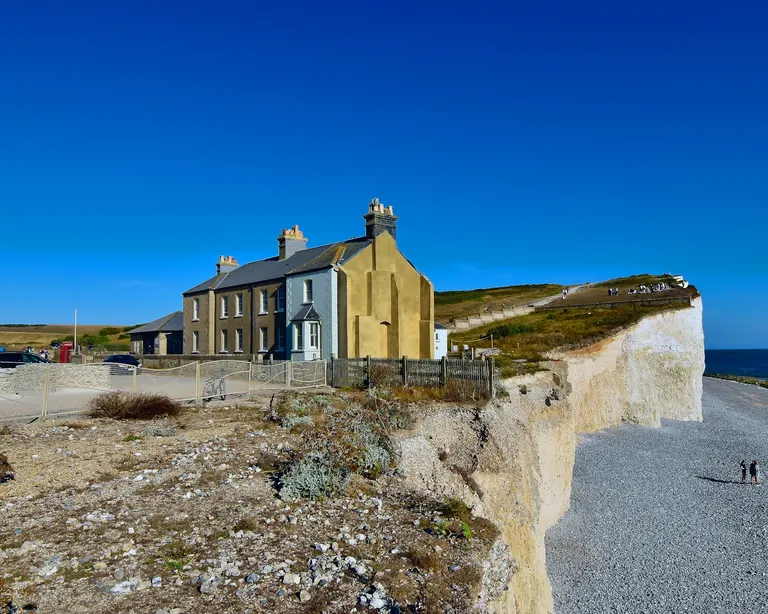
Beach sand and pebbles come from whatever is nearby. Some fall from the local cliffs and some wash down the rivers, but a great deal is sediment left on what's now the sea floor during the ice ages, dumped by glaciers in the north and broken out of the chalk by frost in the south. As the sea rose it swept that sediment ashore, and many beaches, Chesil among them, are a one-off stock that isn't being topped up. The waves sort it all by size. Big, stormy waves throw pebbles up the beach and leave them there, and calmer water drops sand.
The beach below a chalk cliff is usually shingle. The chalk itself washes away as fine mud, but the flint in it is nearly indestructible. Birling Gap and Brighton have pebble beaches for that reason, and the great shingle banks of the south and east coasts, like Chesil Beach, the headland at Dungeness and the long spit (a finger of shingle) at Orford Ness, are mostly flint. Chesil runs for about 29 km, and its pebbles get steadily bigger from pea-sized at the western end to potato-sized at Portland. There's an old story that fishermen landing at night could tell where they were by the size of the stones.
Cornish sand is broken-down rock, largely granite, mixed with a lot of crushed shell, as at Porthcurno. The white beaches of the Hebrides, like Luskentyre, are rich in crushed shell, which is also why the water over them looks so tropical. Waves that hit the shore at an angle nudge sand and shingle along the coast, and where the shore turns a corner this drift keeps going and builds out spits like Spurn and Blakeney Point.
Look for Flint pebbles under chalk cliffs, and groynes (low fences running down the beach) built to stop the sand and shingle drifting away.
Where to see it Dungeness , Chesil & The Fleet, Orford Ness , Porthcurno , Luskentyre , Spurn
White cliffs, red cliffs
A cliff is the colour of its rock
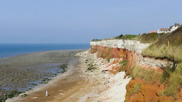
A sea cliff shows the true colour of its rock. White means chalk, as at Dover or the Seven Sisters. Red means sandstone or mudstone stained with iron, like the desert rocks of east Devon at Ladram Bay and of St Bees Head in Cumbria, or the Old Red Sandstone of Orkney and the Angus coast. Dark grey, crumbling and slumping cliffs are usually Jurassic mudstone and shale, full of fossils, at Lyme Regis, Kimmeridge and Robin Hood's Bay. Golden cliffs, like those at West Bay, are sandstone, and black, columned ones are lava, as on Staffa.
Hunstanton in Norfolk shows three colours at once, stacked like a sandwich, with brown carrstone (a gritty, iron-rich sandstone) at the bottom, a band of red chalk in the middle and ordinary white chalk on top. The highest sea cliffs in Britain are on St Kilda, about 430 metres, and England's highest is Great Hangman on the Exmoor coast, with a seaward face of about 244 metres.
Look for The colour of the freshest rock in the cliff face.
Where to see it Hunstanton Cliffs , White Cliffs of Dover , Ladram Bay , Kimmeridge Bay , West Bay , St Bees Head
Arches, stacks and coves
What the sea does to a headland
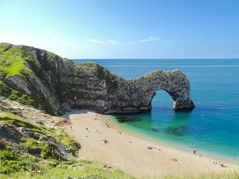
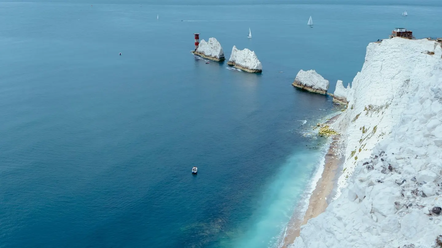
Waves wear away the weak spots first, like cracks and softer beds. On a headland that often means a cave, and when caves worn in from both sides meet, they make an arch, like Durdle Door or the Green Bridge of Wales. When an arch's roof falls in, the far end is left standing alone as a stack, like Old Harry Rocks, the Needles, Elegug Stacks and the Old Man of Hoy. Stacks topple in the end too; the Needles lost a tall pinnacle called Lot's Wife in the 18th century.
Where soft rock lies behind hard, the sea breaks through the hard band and then scoops out the soft rock behind it. Lulworth Cove is a textbook example. A stream cut a notch through a narrow wall of hard Portland limestone, the sea got in through the gap and hollowed out a round bay in the soft clays and sands behind, and the erosion slowed when it reached the tougher chalk at the back.
Look for Caves at the foot of headlands, and arches, stacks and stumps offshore.
Where to see it Durdle Door , Lulworth Cove , Old Harry Rocks , The Needles , Old Man of Hoy , Elegug Stacks
Rias and sea lochs
Valleys the sea moved into
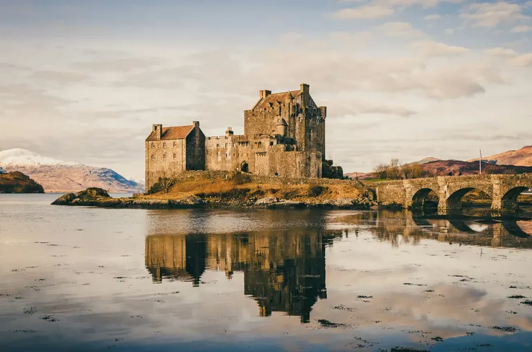
At the height of the last ice age so much water was locked up in ice that the sea was about 120 metres lower than it is now, and you could have walked from England to the continent across land that's now under the North Sea. As the ice melted the sea rose, cut Britain off from mainland Europe around 8,000 years ago, and ran up into the river valleys. In the south-west the drowned valleys are called rias. They're long, branching, wooded creeks, like the Helford, home of Frenchman's Creek, and the so-called estuary at Salcombe, which is really a ria. Milford Haven, in Pembrokeshire, is a ria too, and one of the world's great natural deep-water harbours. In the west Highlands glaciers had deepened the valleys first, so the drowned ones, the sea lochs around Eilean Donan, Knoydart and Moidart, are long, deep and steep-sided, like the fjords of Norway.
In Scotland the land has been moving too. The weight of the ice pressed it down, and it has been rising back up ever since, by up to about a millimetre and a half a year where the ice was thickest. Old shorelines have lifted clear of the sea as flat raised beaches, with sea caves in the former cliffs behind them, like King's Cave on Arran. On the west coast of Jura, bare shingle beaches lie stranded in terraces up to about 40 metres above the sea. At the other end of the seesaw, southern England is sinking by up to about a millimetre a year.
Look for Winding wooded creeks, deep narrow sea lochs and grassy terraces above the beach with caves behind them.
Where to see it Eilean Donan Castle , Frenchman's Creek , Salcombe , Knoydart, King's Cave
Dunes and machair
Sand the wind blew inland
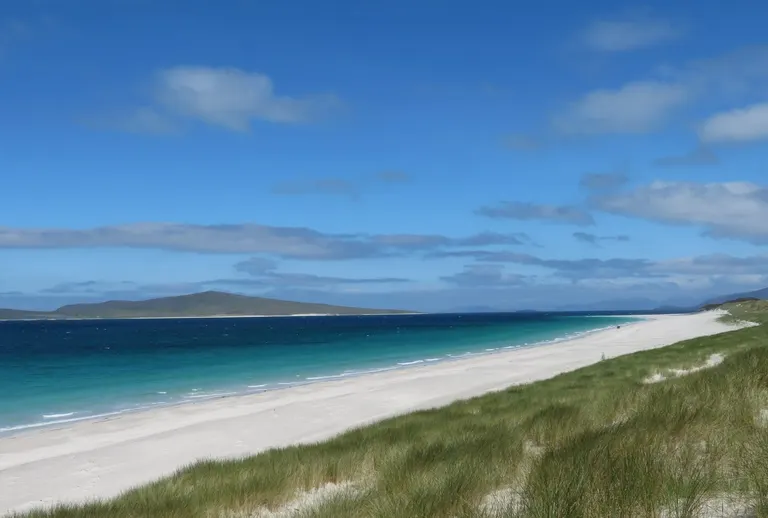
Where a wide sandy beach dries out at low tide and the wind blows onshore, the sand is carried inland and piles up as dunes, held down by the roots of marram grass. Big dune systems like Braunton Burrows behind Saunton Sands in Devon, Kenfig in south Wales, Newborough on Anglesey and Forvie north of Aberdeen are wild, strange places to walk. Dunes can move, too. At Culbin on the Moray Firth the sand, loosened by people pulling marram for thatch, crept over an estate for years until a great storm in 1694 finished it off, and the next year the Scottish Parliament banned pulling marram. Kenfig lost its medieval town to the sand.
On the Atlantic coasts of the Outer Hebrides the sand is shell, and where the wind spreads it inland it makes machair, a Gaelic word for low, flat, lime-rich grassland. It's farmed lightly, and each summer it turns into one of the finest wildflower meadows anywhere. Machair is found only in north-west Scotland and the west of Ireland. The machair on South Uist, behind the beach at Berneray and at the RSPB's Balranald is where you might hear a corncrake, a rare bird with a rasping call.
Look for Marram grass on the dunes, and flower-filled grassland behind a white beach.
Reading the villages
Read the walls
Why the villages change colour from county to county
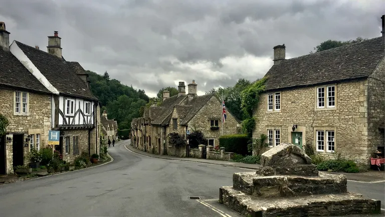 LimestoneCastle Combe
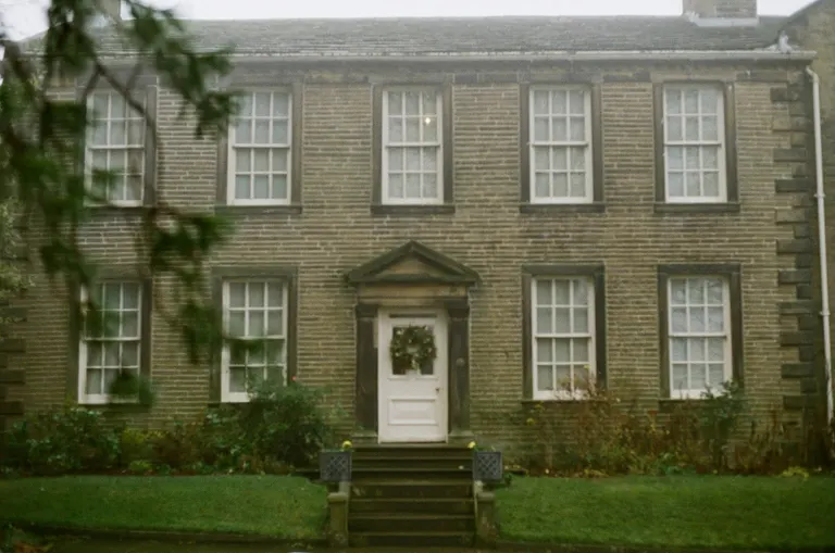 GritstoneHaworth
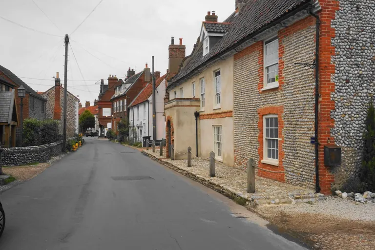 Flint and brickCley next the Sea
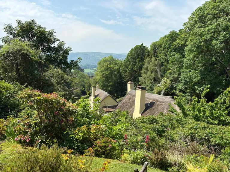 Cob and thatchSelworthy
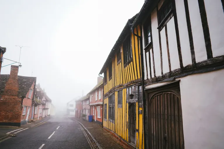 Timber frameLavenham
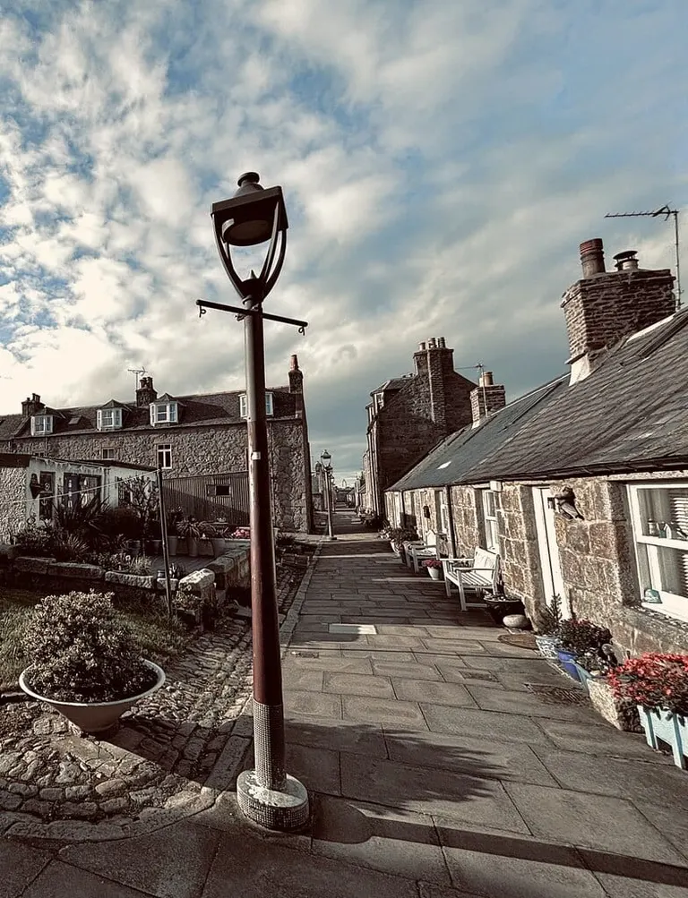 GraniteFootdee (Fittie)
Before canals and railways, stone was too heavy to cart far for ordinary buildings, so people built with whatever was under their feet, and an old village is a geology map you can walk through. Honey-gold Cotswold villages like Castle Combe are Jurassic limestone. Pennine towns like Haworth and Hebden Bridge are soot-blackened gritstone. Chalk country has little good building stone, so people built with flint, often split to show its glassy black face, trimmed with brick. North Norfolk villages like Cley next the Sea are flint and brick, and East Anglia has most of England's round-towered churches, perhaps because a round tower needs no squared stone for its corners.
Where there was no stone at all, on the clays of Suffolk, Essex and the Weald, old houses are timber frames filled in and plastered, like Lavenham's, or brick and tile baked from the clay itself. In Devon and west Somerset the red earth went into cob, walls of mud and straw built up in layers and limewashed, under thatched roofs, as at Selworthy. Slate villages in Eryri and the Lake District, granite in Aberdeen's Footdee and on Dartmoor, and Orkney's flagstone at Skara Brae all follow the same rule.
Field boundaries work the same way, with drystone walls where there was stone to clear off the fields and hedges where there wasn't. The Yorkshire Dales alone have more than 8,000 km of drystone wall.
Look for The colour of the church tower, which is usually the colour of the nearest quarry.
Where to see it Castle Combe , Haworth , Cley next the Sea , Selworthy , Lavenham , Footdee (Fittie)
For the labels on the places themselves, from SSSIs and National Landscapes to Munros and fells, see the glossary. Or open the map and go and look.
Photo and map credits
- Rock map: contains British Geological Survey materials © UKRI, from BGS Geology 625k (DiGMapGB-625), used under the Open Government Licence, simplified and regrouped by the Albion Guide.
- Ice sheet: BRITICE-CHRONO reconstruction, Clark, Ely, Fabel and Bradley (2022), PANGAEA, CC BY 4.0; the furthest extent of their reconstruction between 31,000 and 15,000 years ago, simplified.
- The Needles (header), photo Ben Elliott / Unsplash
- Suilven, photo Chris Lines / Unsplash
- Ben Lawers, © a.poll_o / Wikimedia Commons · CC BY-SA 2.0
- Tryfan, photo Neil Thomas / Unsplash
- Haytor, photo Nick Fewings / Unsplash
- Staffa, photo Desiré Kranenburg / Unsplash
- Pen y Fan, photo guo fengrui / Pexels
- Malham Cove, photo Greg Willson / Unsplash
- Bamford Edge, photo Zhi Xuan Hew / Unsplash
- Ladram Bay, photo Red Zeppelin / Unsplash
- Bibury, photo George Hiles / Unsplash
- South Downs, photo Andras Stefuca / Pexels
- Harrison's Rocks, © Marathon / Geograph · CC BY-SA 2.0
- The Naze, © Christine Matthews / Geograph · CC BY-SA 2.0
- Nant Ffrancon Pass, © Andrew Woodvine / Geograph · CC BY-SA 2.0
- Devil's Dyke and Saddlescombe, © Chris Thomas-Atkin / Geograph · CC BY-SA 2.0
- North York Moors, photo ANA TINCA / Pexels
- Wistman's Wood, © Ian Capper / Geograph · CC BY-SA 2.0
- Glen Affric, © Mike Pennington / Geograph · CC BY-SA 2.0
- The Cairngorm Mountains, photo Simeon Mirkov / Pexels
- New Forest, photo Neil Cooper / Unsplash
- River Test, © Malc McDonald / Geograph · CC BY-SA 2.0
- Sgwd yr Eira, photo Anthony / Unsplash
- Glastonbury Tor, photo Niklas Weiss / Unsplash
- Birling Gap and Seven Sisters, photo Geoff Oliver / Unsplash
- Hunstanton Cliffs, photo Mark Timberlake / Unsplash
- Durdle Door, photo Belinda Fewings / Unsplash
- Eilean Donan Castle, photo Sourav Bhaduri / Unsplash
- Berneray West Beach, © Gordon Hatton / Geograph · CC BY-SA 2.0
- Castle Combe, photo Olivier Collet / Unsplash
- Haworth, photo Hannah Smith / Unsplash
- Cley next the Sea, © Bill Boaden / Geograph · CC BY-SA 2.0
- Selworthy, © Bill Boaden / Geograph · CC BY-SA 2.0
- Lavenham, photo Phil Hearing / Unsplash
- Footdee (Fittie), © Iain Lees / Geograph · CC BY-SA 2.0
